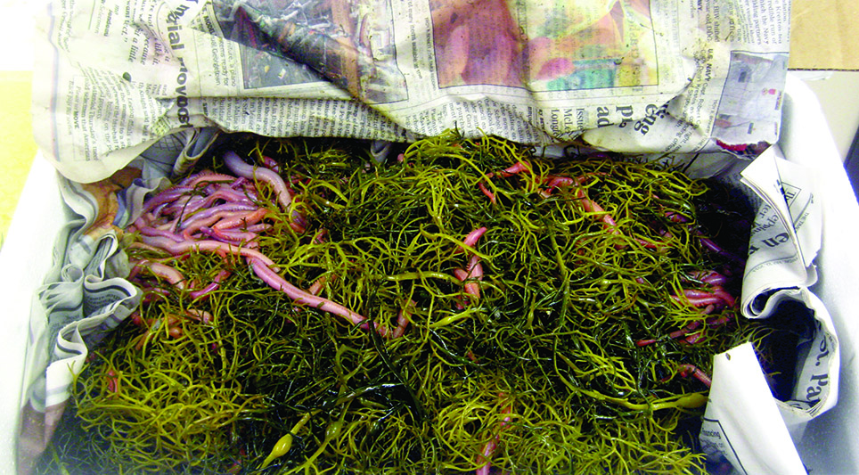
Official websites use .gov
A .gov website belongs to an official government organization in the United States.

Secure .gov websites use HTTPS
A lock ( ) or https:// means you’ve safely connected to the .gov website. Share sensitive information only on official, secure websites.

April 2015

Coastal Ocean Hypoxia Model

A large percentage of South Carolina’s economy is driven by the popularity of beaches as tourist destinations.  Hypoxic (low-oxygen) conditions have been documented in the nearshore coastal waters of Long Bay, South Carolina, during summer months over the past several years.  To maintain a healthy environment for recreation it is necessary to assess the impacts of land use on groundwater discharge to the area.  Researchers measured radon activities of shallow beachface groundwater and nearshore bottom waters to estimate mixing rates and submarine groundwater discharge in Long Bay.  They successfully developed a mixing model based on these measurements, which helped determine that natural phenomena such as limited mixing and submarine groundwater discharge (both previously overlooked) can significantly influence nearshore water quality and lead to hypoxic conditions.  This model can be applied to other types of marine environments to help determine the causes of hypoxia, and as such could be a valuable tool in maintaining coastal water quality, especially in highly developed (urban) areas. 

Coastal Ocean Hypoxia Model Read More>

South Carolina Community Resource Inventory

Community leaders, decision-makers, and staff need detailed knowledge of the resources their community possesses in order to make informed planning decisions that enhance the community while protecting the quality of the environment. Developed in partnership with Clemson University’s Baruch Institute of Coastal Ecology and Forest Science, the S.C. NEMO Program, Carolina Clear, and the North Inlet-Winyah Bay National Estuarine Research Reserve, the Community Resource Inventory provides an atlas of natural and cultural resources available in South Carolina coastal communities.

South Carolina Community Resource Inventory Read More>

Climate and Salinity Intrusion Decision Support Tools Developed for the Yadkin-Pee Dee River Basin

Reduced river flows during drought threaten fresh water supplies in coastal areas because the lower flows allow the salt water wedge to penetrate further inland from estuaries than is normal.  During droughts over the past decade, some coastal drinking water systems and industries monitored threats to fresh drinking water and industrial water intakes due to this salinity intrusion; some have even had to periodically take intakes offline due to high salinities that can damage drinking water treatment systems and industrial equipment. To help decision-makers understand how the frequency of salt water intrusion events may change under future precipitation and sea level scenarios, the S.C. Sea Grant Consortium, the Carolinas Integrated Sciences and Assessments center at the University of South Carolina, and the USGS S.C. Water Science Center adapted an existing decision support system for salinity intrusion in the coastal Yadkin-Pee Dee river basin by adding climate model-based precipitation scenarios and increments of sea level rise to the Model 2 (PRISM2) decision support tool.  This modification is significant in that it allows water managers to explore how often salt-water intrusion events may occur in the Yadkin-Pee Dee River basin under conditions influenced by ongoing and future climatic change.

Climate and Salinity Intrusion Decision Support Tools Developed for the Yadkin-Pee Dee River Basin Read More>

Governors’ South Atlantic Alliance Data Portal

The Governors’ South Atlantic Alliance (GSAA) Data Portal is an online toolkit and resource center that consolidates available state, regional, and federal datasets into one location for Florida, Georgia, South Carolina, and North Carolina. This allows users of the Portal to learn about the region’s data resources, explore a robust repository, and visualize these data via the Portal tools. Developed by the Southeast Coastal Ocean Observing Regional Association (SECOORA) with NOAA support through the S.C. Sea Grant Consortium, the GSAA Portal provides a foundation for long-term collaborative planning in the South Atlantic region for a wide range of coastal uses.

Governors’ South Atlantic Alliance Data Portal Read More>

Low Impact Development in Coastal South Carolina: A Planning and Design Guide

Many coastal decision-makers lack the expertise, guidance, and resources to implement low impact development (LID) techniques for mitigating stormwater impacts. The S.C. Sea Grant Consortium assisted with the development of an LID manual specific to coastal South Carolina that provides guidance on overcoming barriers to implementing best management practices. The project team organized stakeholder workshops, research roundtables, and provided technical assistance with the development of the guide.

Low Impact Development in Coastal South Carolina: A Planning and Design Guide Read More>

Southeast and Caribbean Climate Community of Practice

The Southeast and Caribbean Climate Community of Practice (CoP) brings together individuals from local, state, and federal governments, academia, non-profit organizations and the private sector in North Carolina, South Carolina, Georgia, Florida, and the Caribbean to apply climate science and assess how coastal communities and ecosystems can adapt to the impacts of climate variability and change. The CoP provides a forum for sharing lessons learned and best practices related to climate communication and adaptation. The CoP also provides education and networking opportunities to its members and their stakeholders to increase knowledge and awareness of climate science and to coordinate and perform outreach, extension, and communication related to climate change and its impacts in the Southeast and Caribbean region.

Southeast and Caribbean Climate Community of Practice Read More>

South Carolina Guide to Beachfront Property

Many residents of South Carolina and beyond aspire to live at the beachfront.  To better prepare people seeking beachfront homes (as well as those already enjoying life at the beachfront) regarding specific hazards and regulations, the S.C. Department of Health and Environmental Control Office of Ocean and Coastal Resource Management, with significant contributions from the S.C. Sea Grant Consortium, has produced the South Carolina Guide to Beachfront Property. Included is information on typical hazards homeowners are likely to face (hurricanes, erosion, flooding, wind, and earthquakes), insurance information, and important state regulations regarding construction and renovation practices. 

South Carolina Guide to Beachfront Property Read More>

Assessing vulnerability to sea level rise in Beaufort County, S.C., using facilitated dialogue and visualization tools

The S.C. Sea Grant Consortium, in partnership with the Beaufort County Planning Department, Carolinas Integrated Sciences and Assessments program, Social and Environmental Research Institute, and North Carolina Sea Grant, provided a participatory opportunity for Beaufort County to begin preparing for flooding associated with sea level rise. The project team utilized several available tools to engage local stakeholders in the process. A focus group participated in the Vulnerability and Consequences Adaptation Planning Scenarios process to identify local consequences of sea level rise and explore potential adaptation strategies. Sea level rise visualizations developed with data from NOAA’s Digital Coast Sea Level Rise Viewer tool helped stakeholders understand the risks of future coastal flooding due to rising seas. Public workshops were held to get broader input on adaptation strategies. A final report has been compiled for consideration by Beaufort County Council. This project has initiated a process of community learning that will increase the capacity of Beaufort County to adapt to sea level rise.

Assessing vulnerability to sea level rise in Beaufort County, S.C., using facilitated dialogue and visualization tools Read More>

South Carolina Coastal Communities Initiative Mini-Grants Program

With the vast majority of land-use decisions made at the local level, community officials are instrumental in influencing and directing development and conservation efforts. The S.C. Coastal Communities Initiative is a collaborative land-use planning and water quality small grants program for local decision-makers.  The purpose of the Initiative is to assist coastal communities with the development and implementation of land management policies and practices to reduce polluted stormwater runoff, protect local natural resources, and encourage sustainable development. Coastal communities participating in the Initiative are eligible to receive grants ranging from $2500 to $5000 to address a variety of issues related to open space preservation, natural resource-based planning, water quality management, alternative transportation, sustainable community planning and design, and zoning ordinances and regulations.

South Carolina Coastal Communities Initiative Mini-Grants Program Read More>

South Carolina Coastal Information Network

Forging and maintaining outreach and education partnerships is vital to building and sustaining effective and pertinent outreach programming. The South Carolina Coastal Information Network (SCCIN) enhances coordination of coastal community outreach efforts in South Carolina by avoiding duplication of efforts and minimizing the number of meetings/workshops that community leaders and staff are asked to attend, leveraging scarce resources, and maximizing program benefits and expected outcomes. Through the SCCIN, members strive to provide quality training and educational materials to coastal decision-makers and the public in an effective and efficient manner.

South Carolina Coastal Information Network Read More>

Scroll to Top