Alabama
Biden-Harris administration invests $27 million to support community-driven marine debris solutions through Investing in America agenda
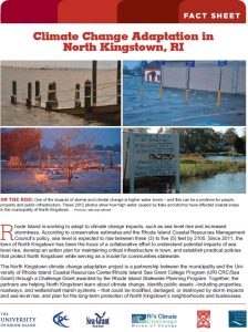
Today, the Department of Commerce and NOAA announced $27 million in funding for projects to prevent and remove marine debris in coastal and Great Lakes communities as part of President Biden’s Investing in America agenda, under the Bipartisan Infrastructure Law.
This funding will support innovative research and foster local coalitions to address urgent marine debris issues by using NOAA Sea Grant’s partnered approach to bring science together with communities for solutions that work.