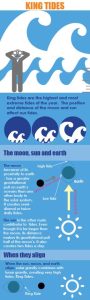
Official websites use .gov
A .gov website belongs to an official government organization in the United States.

Secure .gov websites use HTTPS
A lock ( ) or https:// means you’ve safely connected to the .gov website. Share sensitive information only on official, secure websites.

Post Archives
Tag: Citizen Science

  Scroll down to view posts

Healthy Coastal Ecosystems

All Eyes on the Water

USC Sea Grant is building capacity for a community network to monitor harmful algal blooms in Southern California. HABwatch trains citizen scientists, contributes valuable data to research, and connects scientists with the community. 

Read More >
King Tides
Climate and Hazard Adaptation

King Tides

King Tides, or extreme high tides, offer the chance to view what the future might look like with higher sea levels. The King Tides Project directs citizens to capture images of King Tide events and upload them onto the website. The Washington King Tides project is part of an international collaboration.

Read More >
Southern Maine Beach Profile Monitoring Program
Healthy Coastal Ecosystems

Southern Maine Beach Profile Monitoring Program

Beach profiling is a simple surveying technique used to measure changes in the contour of the monitored beach. The Southern Maine Volunteer Beach Profile Monitoring Program is a unique collaboration among local volunteers, participating municipalities, and scientists, resulting in 15 years of critical data on the status of one of Maine's most vital and valuable natural resources.

Read More >
Coastal Research Volunteer members measure American eels. Credit: New Hampshire Sea Grant
Healthy Coastal Ecosystems

New Hampshire Sea Grant’s Coastal Research Volunteers Help Researchers See the Big Picture

Steve Jones Associated Director of New Hampshire Sea Grant founded the Coastal Research Volunteers with the goal to provide volunteers with opportunities to engage in meaningful science and to benefit scientific research in the region. The program has been going strong for three years and is an overwhelming success, with volunteers helping researchers collect data they would otherwise be unable to collect. 


Read More >
Education

Get to Know the Great Lakes through FieldScope

If you were to pour a bucket of water in your yard, where would the water end up? Great Lakes FieldScope is a new interactive mapping tool that will help explore what happens to that water. Students, teachers, and nature enthusiasts can share and analyze real-world data, including observations they took themselves!

Read More >
Scroll to Top