

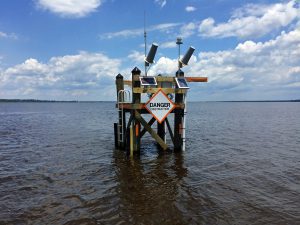
Water Resources: Interactive Visualization Portal Features Network of S.C. Coastal Water Monitoring Locations
S.C. Sea Grant Consortium leads mapping effort after October 2015 floods revealed need for better coordination of available data.
Scroll down to view posts
S.C. Sea Grant Consortium leads mapping effort after October 2015 floods revealed need for better coordination of available data.
Washington Sea Grant partnered with the Jamestown S'Klallam Tribe and Adaptation International to develop a set of local sea level rise projections, and sea level scenario maps for the Jamestown S'Klallam community. The assessments are being used to identify priority adaptation actions, tribal areas or resources that are particularly vulnerable to sea level rise, and have also been integrated into community long-term planning. Additionally, Washington Sea Grant is partnering with North Olympic Peninsula Resource Conservation District and Adaptation International on a multi-sector climate change vulnerability assessment and adaptation plan, including sea level rise and coastal flooding projections for coastal communities in Clallam and Jefferson Counties.
This video was created for Maine citizens to hear and see what their neighbors, town officials, and local scientists have to say about sea-level rise, coastal flooding, and erosion; what it means to them; and what individuals can do about it in the five-part documentary, Building a Resilient Coast: Maine Confronts Climate Change, produced in partnership with Oregon Sea Grant.