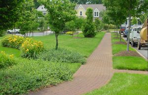
Official websites use .gov
A .gov website belongs to an official government organization in the United States.

Secure .gov websites use HTTPS
A lock ( ) or https:// means you’ve safely connected to the .gov website. Share sensitive information only on official, secure websites.

Post Archives
Tag: Flooding

  Scroll down to view posts

The Watershed Game
Extension

The Watershed Game

The Watershed Game is an interactive tool that helps community leaders understand the connections between land use, clean water and their community.  Participants learn how a variety of land uses impact water and natural resources and learn how their choices can prevent adverse impacts.  

Read More >
Vertical Land Movement Estimates
Climate and Hazard Adaptation

Vertical Land Movement Estimates

Washington Sea Grant is leading an effort to improve estimates of vertical land movement in Washington State, that will be used to improve sea level rise and coastal flooding assessments.

Read More >
Sea Level Affecting Marshes Model Maps
Climate

Sea Level Affecting Marshes Model Maps

Sea Level Affecting Marshes Model maps (SLAMM), will be available on the web in October for all 21 coastal communities. This is being adopted for “planning purposes” by the State Coastal Resources Management Council.

Read More >
Shoreline Change Special Area Management Plan
Coastal Economy

Shoreline Change Special Area Management Plan

To address challenges from a changing shoreline, the Rhode Island Shoreline Change Special Area Management Plan (Beach SAMP) is focused on improving our understanding of how fast erosion is occurring and what areas and infrastructure are at risk of flooding during storms or from future sea level rise.

Read More >
Coastal Property Owner Tours
Extension

Coastal Property Owner Tours

Maine Sea Grant has organized a number of tours, during which Southern Maine coastal property owners, local officials, and community members visit coastal properties in Saco, Wells, and Ogunquit where action has been or could be taken to make them more resilient to flooding, erosion, and extreme storm events.

Read More >
Climate

Kaua‘i Climate Change and Coastal Hazards Assessment (KC3HA)

As a technical report for the Kaua‘i County General Plan update, the KC3HA looks to improve the community’s resilience and preparedness to coastal hazards and changing climate through the better understanding and utilization of coastal hazard information and planning tools. The report compiles and summarizes available science-based coastal and climate hazard information to assist in information the General Plan update.

Read More >
Education

Hawai‘i Coastal Hazard and Mitigation Guidebook

The purpose of the 242 page guidebook is as a resource to reduce the risk to coastal development by planning for natural hazards such as erosion, flooding, tsunami, and hurricanes. The guidebook uses scientific and technically-based standards for hazard mitigation and provides recommendations for implementation (e.g., guidance, industry standards, policy and the use of existing regulations) that minimize burden to the regulated community.

Read More >
Chester City Interactive Inundation Maps
Great Lakes

Chester City Interactive Inundation Maps

The Chester Climate Adaptation Team produced this series of 11 interactive Google Maps to assess the risk to the City's population, infrastructure, and environment from varying levels of flooding.

Read More >
The City of Chester Vision 2020 Climate Adaptation Planning Elements
Climate

The City of Chester Vision 2020 Climate Adaptation Planning Elements

With funding from the 2012 National Sea Grant Climate Adaptation Competition, Chester was selected as a model coastal community for integrating climate change adaptation planning into economic revitalization efforts. Here are recommendations from the Chester Climate Task Force adopted as an addendum to the Vision 2020 comprehensive plan for the City by Chester City Council on June 25, 2014. (PDF, 80 pages).

Read More >
Scroll to Top